Young Adult
Telling, Mapping and Listening to Nashville: Public History and Geography of the New South
$51-100
This program focused on blending traditional resources from the special collection with modern technology to educate students about their city. Students worked with physical maps to locate themselves and their stories within Nashville, then used Google Maps to digitally combine all their stories on one map. Students used oral histories from the library’s collection to map narratives of other Nashvillians.
This program combined genealogy, mapping and oral histories to help create a more inclusive picture of the city. The program was part of a partnership with the Space, Learning and Mobility (SLaM) Lab at Peabody College’s Department of Teaching and Learning and was supported by a Public Scholarship Fellowship from the Curb Center for Art, Enterprise, and Public Policy at Vanderbilt.
Advanced Planning
In the Special Collections Division, we are always trying to find new ways to make our collections accessible to the general public. Our partnership with the SLaM Lab focuses on doing just that. We began planning this program eight months before our first workshop, but that included a lot of brainstorming and research so it would not take as long to adapt to another venue. Our main contact at SLaM, Jennifer Kahn, did much of the leg work for us in developing the program. She brought us the lesson plans, so we just had to find groups.
Marketing
We focused on working with two specific groups: home-schooled students and public school students. Our children’s department has an established monthly home-school program, so we used their electronic mailing list and connections to reach out to the local home-schooling community. Although we were looking for students older than those that attend the children’s programs, we had a great response, and many parents were excited about programming for their older kids. We also reached out to school librarians in our local public school system to see if a class would be interested in taking a field trip to the library to do the workshop. One of the local magnet schools was excited and brought a sixth-grade class for the whole day.
Budgeting
We got our expenses covered through a grant from the Curb Center for Art, Enterprise, and Public Policy at Vanderbilt. This allowed us to get many great materials. We printed out large tabletop maps and placed mylar on top of them so students could draw their geographic stories. We also purchased some additional headphones and splitters for listening to oral histories. Otherwise, we used the library’s computer lab for the digital component and other activities. If necessary, this could be done on a very limited budget by using maps from the library’s collection and not allowing students to physically draw on them.
Day-of-event Activity
Day of, we had two students from Peabody, two staff members, and two teachers (when with the public school).
We set up the computers before the students arrived and loaded them with the oral history clips that they would be listening to, as well as some of the websites they would be visiting. We also set out chairs away from the computers so that students could have focused discussion time (a lesson learned after the first group couldn’t look away from their screens). During the program, library staff helped in the break-out sessions and individual work, troubleshooting and answering questions.
Program Execution
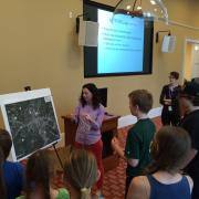
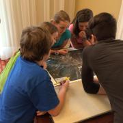
We did the program with 8 home-schooled students, followed by 26 public school students. When the students arrived, they were given an introduction to the tools of a geographer, different types of maps, and the idea of maps telling stories. Students were then broken into groups of four or five and gathered around a table with a large map covered in mylar to try to find their homes, school and favorite places in the city. These clear sheets were then layered on top of each other to demonstrate layering and other concepts of GIS.
We then explored some digital maps that looked at demographics for Nashville. After an intro to Google Maps, the whole group listened to a clip of an oral history from our New Faces of Nashville collection, which focuses on stories of immigrants and New Americans in Nashville. The leader showed how to map the locations from the story on Google Maps, and then the students broke up into pairs to listen to different clips and map those stories. Students were then invited to map their partners' “biogeography.” All of these stories were mapped on the same account so that they could be viewed together.
Advice
This is a great way to engage young audiences with their city and show the diversity of your community. Make sure you build in time for discussion. Students had great questions about why certain groups live in certain parts of the city, how things change, and why all of these stories overlap. Also, if you can contact the group beforehand, ask them to do a short genealogy of their family. We found that many of our students are native Nashvillians while their parents travelled across the country or world. It is also important to have a good Internet connection. The first program was held using our wifi and the credentials kept expiring, making the students reconnect to the server.


